
It was time again for my annual 14er bagging expedition, what with both kids being in camps for a couple of weeks. I'd spent the last few summers in Lake City and the San Juans, but this year I wanted to try some of the peaks in the Sangre de Cristos near the Great Sand Dunes. This range holds some of the most difficult 14ers in the state, but there are still several I thought were within my ability. My first outing would target the double of Challenger Point and Kit Carson Peak.
14,081' Challenger Point is accessed from a trail head just east of the small town of Crestone. From our hotel in Salida, it took a little over an hour to get there, and Nicole, Laurie and I were on the trail at 4:15 AM. The monsoons were in full swing, and every day showed a decent chance of afternoon storms. This hike would be in the neighborhood of 15 miles with about 6,000 feet of gain, so we hoped we had left early enough to summit before those storms inevitably rolled in.
We began with a 5 1/2 mile hike to Willow Lake. Tons of vegetation, a lot of waterfalls and very buggy on the return trip. Just walking the trail was enough to get our clothes pretty wet from the moisture the plants were holding from the night.
 |
| Dawn |


It was a steady, often muddy climb of nearly 3000 feet before we got to Willow Lake about 3 1/2 hours after we started.

It was really pretty. You can just make out in the picture above a small drainage waterfall in the very back of the lake. This waterfall came from a 200 foot cliff above the lake that we would be working our way on top of (from the side...we wouldn't have to climb it directly) in order to access the basin above that was the beginning of a 2100 foot climb to the summit ridge. Note the very small, thin col near the top center of this picture below. That was where we would crest the ridge.

The picture really does it no justice. It was a LONG way up, and the terrain is notoriously bad to get there. On the way up you hit everything from mud to loose dirt to very loose scree. There were maybe a couple easy class 3 moves required near the top, but otherwise it was just a loose, steep slog. We started our way up, one step at a time. The Challenger summit was not visible, but Kit Carson did loom nearby the entire time.

I generally lead while Laurie and Nicole followed shortly behind me.

Around maybe 13,200 feet, we met a couple who had been zigzagging near the ridge crest but never went beyond it. They said they couldn't find a place to get on top, that they would run into cliffs and have to turn around. They gave up and started to head back down before the storms came in. Our group decided to keep going, and near about 13,500 feet we saw another person come down from the notch at the ridge. He told us generally where to go to have the best chance to get to the top, which wasn't near where the other two had been and where I thought we were supposed to go. Without his input, I'm not sure we would have made it to the top.
About this time, Laurie and Nicole were concerned about the terrain and the time. Distance wise we didn't have a whole lot left, but what was left would be slow and very loose. From where I was, I thought I could make it up, so we decided to split up and Laurie and Nicole would wait for me back at Willow Lake. I would try to get to the Challenger summit, but Kit Carson would have to wait until next time. Remember the col a few pictures above? This is me about halfway up it.

Just above me, I saw the notch I was trying to work through. The terrain was pretty steep, but I felt comfortable climbing it, especially alone with no one below me to worry about knocking any rocks into.

When I finally got through the notch, nearly 7 hours after we started, I was greeted with an amazing view to the west.

And I could finally see the true summit of Challenger Point to my south.

From here, I had a short scramble to my left onto the summit ridge, which I followed to the summit at about 11:30. There was a plaque there commemorating those lost in the Challenger explosion in 1986. You couldn't help but to bow your head in reflection here.

This was the view back into the basin. Willow Lake would be back and to the left.

To the southeast, Kit Carson was just a saddle and quarter mile away, and the Crestones were a mere mile and a half behind that. This was my first closeup view of either. Just, wow.
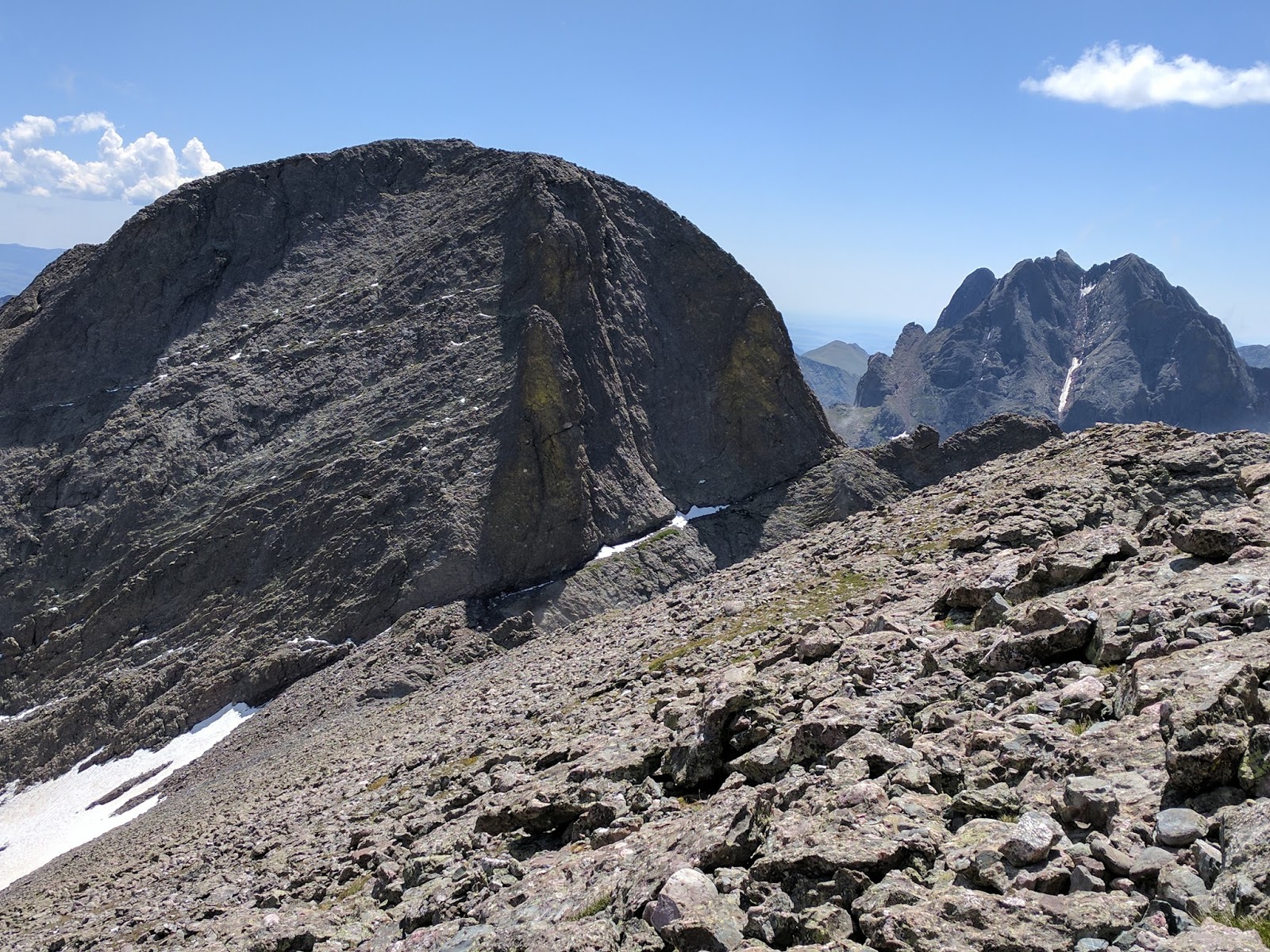
A closeup of Kit Carson. The route up it drops a couple hundred feet into the saddle, then makes its way up the thin snow line pointing off to the right (called Kit Caron Avenue). You take that completely around to the back side, where you make your way back up some more class 3 scrambling a few hundred feet to the summit. Not long, but too long to hit today.

On the eastern side of the same basin that held the Crestones, Humboldt Peak showed its characteristic pyramid shape. I would be attempting Humboldt on Friday.

Challenger Point was my 33rd 14er. Not enough people there to do my traditional finger pose, though.

Here is a video of the summit.
I knew Nicole and Laurie were waiting, so I didn't stay up on the summit very long. I slowly worked my way back across the ridge, through the notch and back down the steep wall toward the lake. The grass that provided the best footing on the way up was very slick now, and multiple times I had to catch myself as I slipped. It was not a pleasant descent to say the least.
I made my way to the top of the waterfall and around the lake, then dropped down a short but steep rocky section to a big campsite.

Unfortunately, I hadn't seen the rest of my climbing party and regretted that we weren't more specific about exactly where at the lake we would meet when we split up. I yelled a few times but got no reply. I saw a couple hikers coming down, but none had seen anyone by the lake. On the way up, we took a short side trail to the edge of the water, and I thought maybe I'd head back up that way to see if they might be there. After nearly 9 hours on the trail, the thought of backtracking a quarter mile back up to the lake didn't make me happy, but I needed to find those two. Fortunately, they were indeed relaxing by the water's edge and we had just simply missed each other as I passed by. We hung out a few minutes and I tried unsuccessfully to eat a PB sandwich. I also realized I had completely drained the 3 liters of water I had hauled up, so I had to steal some from Nicole. I felt like a zombie, and I knew we still had another 5 miles to hike to the trail head. Ugh.
With a couple miles to go, the rains that had generously held off until now opened up a bit. Not a lot of lightning, fortunately, but still enough to get us pretty wet. It actually felt pretty comfortable until the sun would poke through and turn the place into a steam bath. And did I mention the mosquitoes? Yeah, they had woken up and were saying hi. 12 hours after we started, we finally made it back to the trail head.

I knew when I planned it that this would be one of the hardest hikes I would ever do, and that proved to be right. It was a lot of hours, a lot of miles and a lot of elevation gain on poor terrain, but I was pleased that I had at least gotten on top of one summit this day. Our next attempt would be Mt. Lindsey, and my hope was that the long length of this hike would make that 9 mile hike go a lot quicker. The Sangres were as beautiful as I had imagined, and I couldn't wait to see more of them this week.
No comments:
Post a Comment