The 2017 climbing season came and went with much less than opportunity than usual for peak bagging, and I had only summited four 14ers. The latest I've ever done one was in September, and here it was December when all the high peaks are usually covered with snow and the hiking often starts miles before the summer trail heads. However, this winter has been particularly dry, and as I followed the peak conditions, there were reports that some routes were getting pretty clear. Pikes Peak (14,110 - 14,115 feet tall, depending on your source) was the last Front Range 14er on my list, and two days before the weekend I saw the words I'd been waiting for in its condition report: "Trail clear". The summit cam confirmed this...it appeared bone dry. And to make it even more tempting, the weather on Saturday Dec 2 in Colorado Springs was supposed to be in the 60s and clear! The weekend looked free, and so I planned by attempt.
Pikes Peak is one of two 14ers on which you can drive to the top, and I've done that. It also has a really cool cog train that I've also ridden to the top. Hiking it is a bit more involved, as the two main routes are 14 and 25 miles roundtrip. The 14 mile northwest slopes route, starting from the Crags Trailhead near Divide CO, is a class 2 hike, 4000+ vertical feet up the back side of the peak. It only very recently reopened after being closed for several weeks to remove a bunch of dead trees that were determined to be a hazard along the road and trail.

One of my former kickboxers was kind enough to put me up for the night in Colorado Springs the night before, so the drive to the trailhead was only about an hour instead of the three it would have been directly from Longmont. Without fear of afternoon weather, I planned to start hiking around sunrise, which ended up being 7:00 AM.
I brought a few layers, including my shell and a winter jacket because I wasn't sure what it would be like that day. The temperature at the trailhead was in the 30s, and with a full pack and an initial climb, my experience was that I wouldn't need the heavy jacket, as the climb would quickly warm me up. And I was right, at least for awhile. The first couple of miles was a pretty gradual incline through the woods. There was a really cool rock formation that the trail skirted around.

I was getting warm to the point that I considered removing my long sleeves, but as I got above treeline, it began to feel a bit colder. The wind wasn't so bad yet, but the sun was still on the other side of the mountain, so it was chilly. Above treeline, the trail climbs a pretty steep slope to about 12,700 feet. It reminded me a lot of Belford, just a relentless slog uphill but without all the switchbacks. I was stopping pretty frequently to catch my breath, all the while noticing the sunlight moving toward me as the sun rose higher. When it finally hit me, I was temporarily recharged and warmed up. I decided I had made the right choice to leave my heavy jacket in the car.
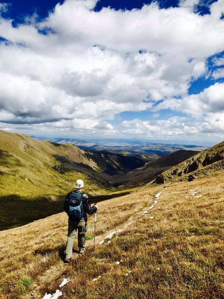
At the top of this ridge, one can see the summit which is still over 3 miles away.

I knew a lot of the climbing was now behind me, and I looked forward to a long, much flatter walk along the road to the summit. At the top of the ridge, the trail passes just below Devil's Playground, and 13er Devil's Playground Peak. It was only a couple hundred feet to the summit, and I planned to go over it on the way back down.


From this point, the route flattens considerably. The trail follows along the road to the summit, and the sections that went downhill felt great after the climb I had just completed. Another 13er, Little Pikes Peak, was next to the trail closer to the summit (see the first picture above, Little Pikes is on the right). This would be another easy bag on the way down.
It was along this stretch that the wind really started to get to me. I put on my balaclava and my heavy gloves along with my winter hat and the hood of my shell, and that helped somewhat as long as I kept moving. I tried to drink every few minutes and blew the water out of my line to try to keep it from freezing, and I only had one "oh crap" moment that it did freeze up but I was able to knead it out before it got too bad. After about 6 miles, the last half mile was the class 2 scramble to the top. The basin below looked amazing.

In the picture above, Little Pikes is right of center along the road, and Devil's Playground is just behind those cliffs on the right. That back ridge is where I had initially come up. Below, the view is more to the southwest, with the southern Sawatch Range and the northern Sangre de Cristo Range in the distance. It was windy, but the view was endless.

The summit block was frosty, and it was slippery and slow going to the summit.

Unfortunately, I had to stop frequently, and I had become very cold with the wind. That last half mile and 1000 feet to the summit took nearly an hour, and the summit is large, flat and very open to the wind, which was howling. I made my way to the summit house and snapped a quick picture of me at the summit sign. 14er number 37 had been bagged.

In the summit house, I was too cold to partake of the world famous donuts that the snack bar boasted. I made my way to a booth, took off my head gear, put my head on my arms on the table and shivered. I had a couple energy bars and rubbed my arms and body to try to warm up. After about 20 minutes I thought I needed at least one picture from the summit, so I made my way to the viewing platform on the east side of the summit and snapped a shot of Colorado Springs below.

The wind was still awful, and I practically ran back into the summit house to try to warm up again. There were several people up there that had driven, and I considered trying to hitch a ride back to Devil's Playground (the road itself went down the east side of the mountain, so Devil's Playground was the last stop via car before the road split from the trail). That seemed like it was cheating, though, but I thought maybe I could at least walk the road down from the summit which was a little longer but much easier travel than going back down the slippery summit block. Unfortunately, a not so subtle sign said "no pedestrians" past the summit on the road. Oh well, back down the way I came it would be.
The scramble down wasn't as bad as I expected, and I was able to take some video once I had a little break from the wind. The 3 miles of flatter trail that were refreshing on the way up suddenly become more challenging with every slight incline on the way back to Devil's Playground. Still, there was great scenery all around.
The summit block behind me:

Looking east down a gully along the road:

A rock formation near Devil's Playground. Many rock formations up here reminded me of Garden of the Gods, which wasn't terribly far away.

From Devil's Playground Peak, looking at the ridge I would drop over. I ended up not summiting this peak nor Little Pikes, it was too windy and I was just too cold.

Looking back across the basin to the summit in the distance.

The top of the ridge had a marker, and from here it was all downhill.

Dropping off the ridge. You could see forever from to the west.

The further down the slope I got, the less wind there was, until finally in the trees it had essentially stopped. The long hike had worn me down, but at least I was warming up again. After 8 hours of hiking and nearly 14 miles, I returned to the trailhead at about 3:30. Mission accomplished.
It seems I am far to frequently under-prepared for some of these hikes. I was aware that it tended to be windy in the winter, but a favorable forecast at lower elevation lulled me into thinking this day would be different. It was not, and next time I'll be better prepared, but this time I was still able to safely summit and return. Colorado could use some snow, but I was glad I could take advantage of the dry conditions to again enjoy the scenery one can only see in the high elevations. As hard as they are, I'm always thankful that I have the ability to do these hikes, and the reward for tackling these challenges is always worth it, without question.
And with that, the extended 2017 14er climbing season appears to have come to an end for me with five total summits. Let the training and conditioning begin for next summer, where the challenges become much greater!