
I have been anxiously following the snow conditions in the high country, patiently (sort of) waiting for enough snow to melt so that the high peaks would be accessible without any snow gear. With the amount of snow we got this winter, I expected it would be at least the end of June before many peaks no longer had enough snow on them to make things difficult. As a lead up to "14er season", my friend Nicole and I had planned a relatively easy climb of 13er Squaretop Mountain off of Guanella Pass. Conditions looked good and we planned to leave about 5:30 AM for the two hour drive to the trail head to tackle this bicentennial peak.
However, Saturday evening, about 12 hours before we had planned to leave, I saw a condition report for Mt. Antero which said "a few snow fields, 90% avoidable". And just to make it a little more enticing, someone had posted a video of a creek crossing that is generally known as the most difficult part of the 4wd road to the upper trail head, and Nicole had a WAY more capable vehicle with her Rubicon than this person had with their 4Runner. Hmmmm... Could we possibly do Antero instead of Squaretop and start our season tomorrow? I texted Nicole, asked her if she was up for Antero, and in true Nicole fashion, she responded "yep, what time should we leave"? And at 3:00 AM the next morning, we started our 3 hour drive to Nathrop to bag our first 14er of 2016.
Mt. Antero is in the Sawatch range at 14,269 feet, the 10th highest 14er in Colorado. The round trip hike from the 2wd accessible trail head is 16 miles and 5200 feet of gain, much of it following a rocky 4wd road. However, with the right vehicle, you can reach the upper 4wd trail head at 12,000 feet (and continue up over 13,000 if you wanted) and reduce the distance to about 7 miles. Option B sounded much more appealing, so after we initially drove right past the 2wd trail head and having to come back to find it (it was early), we started up the Baldwin Gulch road in Nicole's Jeep.

In early summer, there is a creek crossing that is generally considered the make or break point for this road, as it flows pretty heavily with the snow melt. I don't remember how long it took to drive the 3 miles to this point, but it was probably about 45 minutes. And then we came to it.

Based on the video I had seen earlier, we didn't hesitate and Nicole plowed her way through the creek with no problems. After another mile, we were at 11,800 feet and encountered a snow drift that forced us to park, but not before we had cut over 8 miles of hiking off of our day.

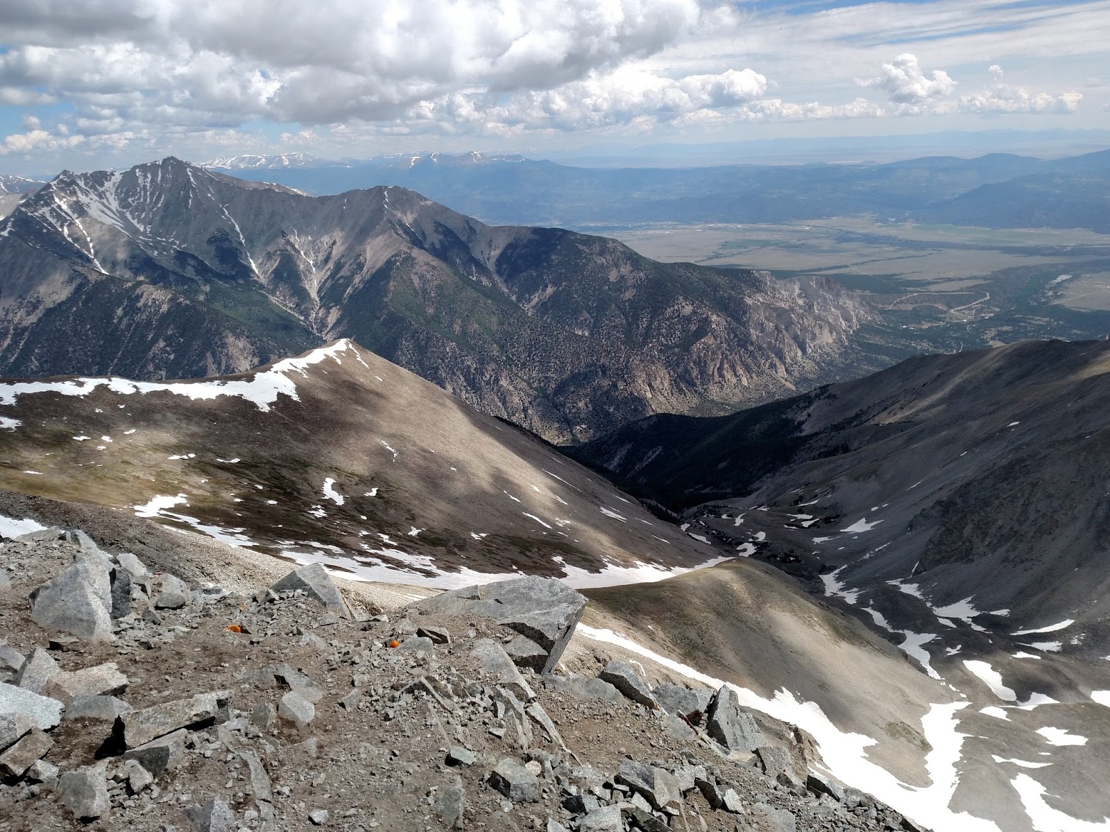
We were right at tree line, and the weather that morning was perfect and clear. The view back down the road was a great start to the day.

At 7:10 AM, we gathered our gear and started to hike up the road. Much of the standard route up Antero follows this road, and it was really easy to see it switchback up the slopes in the distance. On the one hand, it was good to see where we were going, but on the other, some of the "next sections" seemed awfully far away. No matter, it was usually a steady but manageable climb upward.
While we made our way out of the initial valley, we could see Cronin Peak to the southwest.

Along the way, there were a few snow fields on the road, particular on the switchbacks themselves, but occasionally we had to cross over a drainage area that had a continuous line of snow that cut right through the trail but was not usually too difficult to walk across.

The section above was sketchy because in the morning, the footprints were iced over and not terribly deep. And the snow continued downslope for a really long way, so a slip here would not have been fun. As I slowly made my way across, I was ready to try to dig in my pole in case I lost my footing and hopefully prevent myself from sliding very far, and fortunately I didn't have any problem. Many of the snow fields in the switchbacks we were able to avoid by cutting uphill a little earlier and picking up the trail beyond the drifts.
At 13,100 feet, we reached an open area that had a great view south of Mt. Shavano and Tabaguache Peak, the 14er pair that Nicole and I had finished our season on last year.

This was also where we happened upon a heard of goats, the sacred inhabitants of the high country. On the way up, they took off down the hill pretty quickly as we approached, but on the way back down, a few of them hung out to see what we were up to.
We continued up the road toward Point 13,800, which had signs around it stating "No Claim Jumping" and "Private Property". There is a lot of prospecting on Mt. Antero (aquamarine is fairly common here), and this was apparently one of those areas.


From the saddle at Point 13,800, the summit was about a half mile away. We first had to traverse a rocky spine that had just enough snow on it to make it tricky in some areas, but it wasn't too bad.


The summit can be seen beyond the end of that spine and was about 400 feet of climb from its base. It was steep but short, and we got up it pretty quickly, taking just under 3 hours total to summit.

Other than a large drift across the northern portion of the summit and a pika, we had the summit to ourselves and stayed up about 20 minutes to take in the views and get some food. The weather was perfect up to here, but storms were forecast for the afternoon, and we saw a couple forming in the area so we didn't want to stay too long. As usual at the top of a 14er, the scenery did not disappoint.
Here is a panorama from the south (Shavano and Tabaguache) across the west to the north (Mt. Princeton). The snow drift on the right side was on the norther portion of the summit.

View to the northeast. Mt Princeton is toward the left. The chalk cliffs are the lighter brown area at the base at the right center of the picture, and that was the the valley we drove through to get to the trail head.
A close up pic to the south. Mt. Shavano is on the left, and Tabaguache Peak is on the right with the snow fields streaming down it.

View to the north. Mt Harvard is the tall peak in the center in the back, with Mt. Columbia to its right. Mt. Yale is a quarter way from the left, slightly closer than Harvard and Columbia. Mt. Elbert is the darker, rounded peak very far in the distance near the left side of the picture, and Missouri Mountain is the snowier peak in the distance on the left edge of the picture.

After about 20 minutes, we headed back down. Once we got past the spine at the base of the summit, it was smooth sailing back down the road, and we cut several corners off the switchbacks to save some time. I always like looking back up to the summit when I can after I'm on my way down because it always seems like it is ridiculously far away, and it gives a real sense of accomplishment knowing that as far as it looks, I was up there.

It took about 2:20 to get back down to the jeep and begin the 4 mile drive back out to good road. It was nearly 2:00 in the afternoon, and we were a little anxious about the creek, as we didn't know how much the water would have risen in the afternoon when I got warmer. Turns out we didn't have any problem, and Nicole carefully made her way back down. Mission accomplished.
I have a few target 14ers I'd like to summit this year, and Mt. Antero was not on that short list, but I was glad that everything came together perfectly and allowed us to bag it, particularly after making such a last minute decision to give it a go. While I'm generally not a great planner, I do try to prepare for more than a couple hours between the mere thought of attempting a summit and actually doing it. This was my 24th summit, and Nicole's 27th (not that I'm keeping track and trying to get back ahead of her or anything). The snow is melting quickly, and it is time to continue exploring the high points of this amazing state. Let the season begin!
