Tuesday, August 25, 2015

Massive!!


The 14er climbing season isn't over yet by a long shot. On Sunday August 23, Nicole, Laurie, Laura, Kim and I piled into Nicole's jeep at 3:00 AM to make the 3 hour drive to Leadville to attempt a summit of 14,421 foot Mt. Massive. There are two main routes up this mountain, one that is a gradual incline but 14 miles round trip, and one that is much more direct at just 8 miles round trip but much steeper. After much thought, and considering we had access to a jeep that could handle the 4wd road to the shorter trail head, we opted for the latter route. In the picture above, the route we would take essentially goes right up the middle the southwest slope of Mt. Massive, pictured above (taken from across the valley on Mt. Elbert).


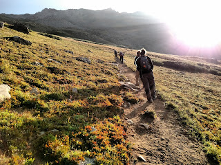
We were a little concerned that the smoke that has made the front range so hazy this week would prevent good views from the top of Massive. While there was still some haze in the air, it wasn't nearly as bad up there as it was in Longmont. The first 1.25 miles of this hike is a very gradual incline on an excellent trail and made for a nice warmup for what we knew was coming up ahead. Early on we could see a layer of fog blanketing the valley below us.


The alpenglow on the surrounding peaks is always one of my favorite parts of these hikes, and it was there again today. This formation was off to the south just beyond the trail head.


And this was 13,852 foot Mt. Oklahoma to our north.


Over a mile in, we came to the trail junction that would begin our trek up much steeper terrain. We climbed up this boulder field first.


It didn't take long to break tree line, and the views that we had heard were quite amazing on this route proved to be just that.


The climb up was a steady one, and we could see above the ridge that was our next goal.


We continued up, and up, and up, and up....


It was above this area that we found a rock formation we called "The Giant Cairn". From the front, it looked like an impressive scramble:


From the back, the "impressive truth" was a little more clear...


And while the cairn below wasn't one to scramble on, its symmetry made it our favorite cairn of the hike (yes, we have things like that on these hikes).


This picture looks back down from most of the way up the slope. It was a relentless elevation gain, but very direct.


Near the summit ridge, we were able to see the view to the north. North Massive, a sub peak of Mt. Massive and the 5th highest point in Colorado, is just right of center in the picture below.


Opposite this view, we had a little further to climb to reach the ridge that would eventually take us to the summit.


Finally we reached that ridge and could finally see the true Mt. Massive summit. The final traverse went across this rocky terrain. The standard route, which we did not take, connects to the route we took in this area.


This view looks back along the summit ridge to the south. South Massive, another sub peak, is on the other side of the saddle to the left of the picture below.


After a 6:30 AM start, we summited about 10:45. Mt. Massive was my 21st 14er.


Though it was a little hazy in the distance, we could still see quite a bit, especially to the west and north.

Massive Green is the nearer peak, and North Massive is in the distance.


North Halfmoon Lakes were below to our southwest. Had we continued on the trail junction at 1.3 miles and not gone up toward Massive, we would have ended up at these lakes.


The town of Leadville to the east, with Turquoise Lake to the north (left) of the picture.


We spent nearly an hour on the summit, lounging on rocks and reducing the loads in our packs by scarfing down the snacks we'd hauled up. Other than a pretty strong wind on the west side of the summit, it was completely calm and perfect weather where we were sitting on the east side.

It took about 3 hours to descend, and we all agreed that this was an infinitely better experience than Mt. Princeton a couple weeks ago although the descent seemed to last a really long time (as most of the descents do).

Nicole, Laura, Kim and I have done several 14ers together over the past couple of years (or months in Laura's case), but this is the first 14er I've gotten to do with Laurie, for whom Mt. Massive was her 17th peak. Laurie's passion for 14ers is as strong as my own, and I have swapped hiking stories with her for the past 3 summers but I've never gotten to actually hike one with her, so that made this hike all the more special for me. She posts a picture of her boots in the foreground with the incredible views from every summit, and it was fun to finally get to see "behind the scenes" of her taking that picture from the summit of Massive (I know, it's the little things. :) )


As is always the case on a 14er climb, this was a very challenging hike, but it was a very enjoyable one. Great trail, great views, and as usual, very enjoyable company with whom to experience it. Although the hike was physically challenging, great stories always come as a result of the journey, and this journey was no exception. Here's to more summits and more stories in the near future.


Wednesday, August 12, 2015

Mt. Princeton - I Wanna Rock!!


On Sunday, August 9th, after waking up to a 1:30 AM alarm, I headed down to Buena Vista to climb 14,197 foot Mt. Princeton with Nicole, Jenny, Kim and Laura. Mt. Princeton did not have a very good reputation as a "fun" mountain to hike, as it was really close to civilization and it was supposed to be quite rocky. Nonetheless, it is on the list, so it needed to be climbed and I would judge for myself just how enjoyable this hike was.

Princeton is another 14er in which the hiking distance can be cut down substantially with a good vehicle, and Nicole's Jeep fit the bill nicely again. It is over 13 miles round trip from the main trail head (pictured above), or that can be cut down to around 7 miles if you take the narrow Mt. Princeton road higher. The most common starting point is a set of radio towers at about 10,800 feet, and that is where we were headed.

We had hoped that all the traffic at 6:00 AM would be heading up and we wouldn't have to pass anyone, and that was almost true. Just up the road, we passed a small white car who couldn't get up and had to turn around, but we were in a good spot to pass him.  Then within a half mile of the towers, we got behind a Subaru that was having trouble getting past a more rugged section of the road. For a few minutes we watched as one person tried to guide the driver up, but her wheels were not gripping and she couldn't make it. Unfortunately, this was NOT a good section of road and passing her was going to be a challenge. She ended up inching over to the drop off side of the road, right on the edge, and Nicole had to gun it along the steeper mountain side wall of the road next to the Subaru. I wish I had video of that move...she pulled it off like a champ, and we made it to the radio towers to start our hike. I have no idea how the Subaru made it back down, but apparently it did because we didn't see it at the end of our day.

We started at about 6:30 AM, and hiked further up the same road we had just driven up for the past 3 miles. Parking was apparently sparse beyond the towers, so we stopped there, but as we hiked along, we realized we probably could have gone up at least another 3/4 of a mile had we continued. Oh well, live and learn. 1.3 miles from the towers, we came to the formal trail junction which would take us around the side of 13,300 foot "Tigger Peak", which is to the south (left) of Mt. Princeton as you look at it from a distance.


The beginning of this trail was very well worn and not too rocky yet. Princeton is off to the right of this picture and is still a couple miles away.


It wasn't long before the route got much rockier. There were frequent cairns down this low, but a fair amount of loose rock we had to walk across and it was pretty slow going. This picture shows the terrain next to and above the trail as we skirted across Tigger Peak.


Though our hike at this point was not steep, this was indicative of what we were hiking across. We eventually made our way up to the saddle between Tigger and Princeton and were rewarded with this fantastic view of Mt. Antero to our south.


The summit of Princeton was above us now, but it was getting more steep and was very rocky. It is just under a mile away in the picture below.


Cairns became more scarce at this point, and we did our best just to aim toward the summit taking the least unclear way we could find. There were occasional worn paths of dirt up here where the trail briefly appeared from time to time, but many were almost too steep to get good traction on, so sometimes the rockier areas were the lesser of two evils. Eventually we made our final summit push up more steep, rocky terrain. (Kim, Jenny and Laura are three of the hikers in this group above me at this point).


Finally, we reached the summit. This shot of Nicole summed up how most of us felt as we finally got up this rocky slog.


The weather was near perfect on this day. There was some wind a bit lower, but it wasn't bad or consistent, and the summit was completely clear and just slightly breezy. Numerous 14ers could be seen in the distance in all directions among all the other peaks.


This was my 20th 14er, and it took almost 4 hours to go the ~3.5 miles to the summit. We unloaded, snacked and enjoyed the view for a good 30-45 minutes.


While we were up there, we met a very cool guy from New Zealand named Andy. He joined our group for the hike back down, and it turned out he was the driver of the small white car that couldn't make it up that we had passed earlier, so we gave him a ride from the radio towers back to the main trail head (and his car). 

We weren't looking forward to the hike down, considering how rocky and steep it was on the way up. This picture shows most of the route (you can see the trail running alongside of Tigger Peak in the background). The majority of the rocky summit block is below the foreground and can't be seen from here.


Jenny and her long legs had a wonderful time making it down this terrain. Nicole could only watch as Jenny danced her way back down.


We also made the hike a little more interesting by descending off the saddle a little too early, so we had to rock hop our way down a more rocky trajectory to the actual trail which we could see ahead of us but seemed to never get closer. There were also a bunch of hairy black spiders in very cool looking webs between many of the rocks we were hiking over. Reminded me of a scene from Harry Potter.

About 7 hours after we started, we finally made it back to the Jeep to begin the ride down the 4wd road to the main trailhead. We did make the discovery that Nicole's Jeep could actually fit 6, even if it wasn't the most comfortable ride for everyone involved.


We had a late lunch, dropped off our new Kiwi friend, and joined a million others trying to get out of the mountains on a Sunday afternoon. It was nearly 8:00 PM before we were finally home, everyone completely exhausted.

So what was the verdict? Yeah, it was not my favorite 14er hike by any stretch. Although the views from the tops of any 14er are spectacular, Mt. Princeton didn't offer much else on the way up, and it was much more rocky than I prefer. However, the view of Mt. Princeton as you come over a pass above Buena Vista (as seen in the second picture above) is one of my all time favorites, and it was rewarding to see the view from the top of this majestic peak. And any opportunity to partake in a hike with friends is an opportunity that shouldn't be passed up. By those standards, it was totally worth it.