Monday, July 25, 2016

Mt. Sneffels - If at First You Don't Succeed


On Wednesday, July 20, fresh off an incredibly successful tackling of  Wetterhorn Peak, I set my sights on another peak that I was unable to summit last year, 14,150 foot Mt. Sneffels near Ouray. Nicole (who was with me on the failed attempt last year) and Laura would be my partners on this climb. We had been watching the conditions on this peak very closely, as there is a col that tends to hold snow very late into the summer that could severely impact our ability to climb the standard route if it were still there. However, there is another route up Sneffels, the SW ridge route, which had been described as now snow free, but this was a class 3 route (versus a difficult class 2 climb for the standard route, assuming there was no snow). The alternate route wasn't just a 100 foot wall at the end that was class 3, though. There were class 3 moves scattered throughout the route, and we were all completely unfamiliar with it. After some consideration, and noting that the alternate route was still only a mile longer on a 3 mile round trip, plus with our new-found confidence on class 3 terrain after our summit of Wetterhorn, we decided to go for the snow free ridge.

Yankee Boy Basin is an incredibly beautiful area, and like last year, we started our ascent just at sunrise and got to see the surrounding peaks light up with the early sunlight. This is 13,700 foot Gilpin Peak on the other side of the basin from Mt. Sneffels.


As this is such a short hike, it didn't take long for our target ridge to come into view.


Blue Lakes Pass is at the bottom of the really jagged part left of center, and that was where we would be headed to start the more technical part of our route. When we got up there, we could look back into the basin from which we approached. 13,786 foot Potosi Peak is on the left.


And we were greeted with the stunning view to the west of Blue Lakes and 13,815 foot Dallas Peak.


And off to our north, we saw our first closeup of the terrain we would soon be dealing with.


The route description was pretty detailed, and we made our way up into the spires that comprised the SW ridge up to Mt. Sneffels. It was much more actual climbing than we had done before, but we slowly made our way up (and sometimes down) various formations and outcroppings that would lead us closer to the summit.


We got through some pretty tricky sections all the way up to about 13,400 feet, when we hit this wall.


You can see Nicole in the narrow crevice below the wall, and it was a real struggle to simply get above that crevice. Once there, however, both Nicole and Laura tried to find a safe route to pull ourselves out of this gully, but with the wet rock and minimal hand holds, neither of them felt comfortable continuing on. We had some soul searching to do, as we were already a good ways up the ridge, and we were dreading having to reverse some of the moves we had to make to climb up this far. We looked down a chute off to the side to see if we could possibly exit that way.


Unfortunately, it was too difficult to tell if the end of that snowfield was a cliff or an escape, so we decided we had to retrace our steps backwards. As scared as I was climbing up this far, I was not ready to quit yet. I knew what the standard route held up to this same elevation (since I had hiked it that far last year), and I told Nicole and Laura that I was ready to try to summit from that side, even with the snow. Not surprisingly, they agreed, as they both wanted to summit as badly as I did, even if it meant starting over again. And we would only have to descend to about 12,600 feet to catch the standard route junction and make our way up it. We still had a lot of fight in us and we weren't ready to give up.

So back down the ridge we went, reversing everything we did to get to where we had stopped, then back down Blue Lakes Pass and on to the standard route. Instead of climbing through a jagged ridge, the standard route began with a 500 foot ascent up a scree filled gully:


This part of this hike is considered by many to be one of the most miserable experiences of any 14er route, and for good reason. Much of the ground is very soft, so with each step you tend to sink backward a bit. It is simply a test of wills to see if you can slowly make your way up the slog as it tries to slow you down with literally every step you take. But eventually, we made it up this gully, and this picture looks back down upon it.


This ridge at 13,500 feet is at the top of the gully (which comes up from the right side of the ridge in this picture), and that rock outcropping is where Nicole and I crouched for about half an hour last year waiting for the wind and clouds to subside. They never did, so we turned around and abandoned our attempt. That was last year.


This year, although there were storms beginning to form in the distance, the weather here was still good to continue. Looking up this ridge to the northwest, we could see Lavender Col.


The snow toward the "top" of this col, as little as it seems to be, would cause us big problems if we tried to get through it without the proper gear, however there was a sideshoot option that would have us climb out of the col about half way up as we reached the snow. A man was sitting at the foot of the snow (in fact, this was the exact same guy that we had run into on our way down from the summit of Wetterhorn two days ago as he was making his way up. Small world.), and he directed us to the left out of the col to a snow free alternative.

This section required some more scrambling that was more technical than I was used to, however our experience just a couple hours ago on the SW ridge really helped me get my mind ready to tackle the rock we would be finding on our new route, and we moved up it quickly. The weird thing about Sneffels is that it is hard to see the summit until you are right on top of it, so it is very easy to get turned around, but we soon had nowhere higher we could go and saw the summit log box laying there, and we knew that we had finally bagged our target peak.


The views again were just spectacular. This view is to the southwest, across Blue Lakes to Dallas Peak which is just touching the clouds toward the left of the picture.


Looking back down the basin to the southeast, Gilpin Peak takes up most of the right foreground with the snow all over its face, and Mt. Emma (~13,500) is just behind it with some thin snowfields of its own. You can see a small lake (Wright's Lake I believe) just left of the center of the picture, and Nicole's Jeep, where we started, is behind the hill bordering the left of this lake, about 2 miles away.


Looking a little further east behind the ridge we were on at 13,500 feet (you can see it in bottom right corner), Kismet Peak is the dark, tall point in the right foreground and Cirque Mountain is the rounded lower peak on the far left surrounded by clouds. Teakettle (13,825) is the very pointy peak to the right of Cirque, followed by the lower "Coffee Pot" and finally Potosi Peak just right of center as you follow that ridge.

This was my 26th 14er summit. (I had to creative with the fingers, since there were only 3 of us on the summit. That's a "2" and a "6", in case it wasn't obvious. ;)


This summit was one of the smallest (maybe THE smallest) summit I've been on yet, which shouldn't have surprised me considering how pointy the summit looks from miles away. We took our pictures and gathered our stuff again, as waves of storms were starting to make their way in. One wave passed to our south and the next looked like it would be a bit closer so we didn't want to stay exposed on this jagged pile of rocks any longer than we had to. Plus we knew the climb down was going to be very tedious with the hard scrambling off the summit and then the steep scree down the gully. We made our way back down. This is Laura and Nicole making their way down to the 13,500 foot ridge which marked the bottom of Lavender Col (which we hadn't even gotten back to yet at this point).


At the bottom of the col, the clouds that had partially obstructed our views to the other side of the ridge lifted, and we could see the peaks of our favorite ridge up close and personal. From the left, Cirque, Teakettel, Coffee Pot and Potosi in the shadows, with Kismet on the front right with the fingers of snow. Truly beautiful peaks, all of them.


Next began our "ski" down the scree of the gulley. There were plenty of terrain options to choose from, and Laura and Nicole chose larger rocks while I made my way to the softer, smaller stuff and essentially stood sideways, locked out my lower, lead leg and did a controlled slide most of the way down. They say the lungs work on the way up and the knees work on the way down, and they weren't kidding here. It was really a challenge not to fall.

Eventually we all made it down though, and we could continue back on much more level terrain the mile or so to the Jeep.


Unfortunately, the waves of storms that had continued to pass south of us had finally made their way far enough to the basin that we could see the next one was going to hit us dead center if we didn't get moving. We picked up our pace as much as we could, watching the not-distant-enough rain blur terrain that was getting closer and closer. The thunder was getting louder. We moved faster. Then it started to sprinkle. We moved faster still. I got out my shell and put it on just as the clouds opened up and it started to pour. We started to jog, still a quarter mile from the car. Then it started to hail, and we were hit with a couple of lightning strikes that were too close to even begin the "one thousa...." count before the thunder crashed immediately. I was in a full on run by now, simultaneously looking for the Jeep around every switchback while also trying to decide the best place to try to ditch if I suddenly felt my hair standing on end from an impending strike. After what seemed like an eternity, we all made it back to the Jeep. We sat for a minute, catching our breaths, uttering a few expletives, and dripping wet. We made it, ten minutes later than we probably should have, but we were safe.

I was really proud of our effort on this one. This was the most technical climb we had attempted to date, and even though we were a good ways in on the initial route, we knew when the terrain was beyond our ability and made the right decision to turn around. My confidence had grown after summiting Wetterhorn, but Sneffels informed me rather bluntly that "no dude, you still have some work to do on your climbing to justify that confidence." In the end, though, we got more experience on some class 3 rock that will no doubt help for future climbs. A hike we expected to take about 4 hours ended up taking over 8 hours, but a hot shower and a change of clothes and a good dinner never felt so good that evening. Mission (eventually) accomplished.

Saturday, July 23, 2016

Wetterhorn Peak - Take 3


The week of my 45th birthday, with both kids in camps, I set my sights on several hikes throughout Colorado with the intention of bagging a few more 14ers. On my actual birthday, July 18th, I had my third go at trying to summit 14,015 foot Wetterhorn Peak near Lake City. The first time I attempted Wetterhorn two years ago, I got within 100 feet of the class 3 summit wall before I got scared and had to turn around.  Last year I had to turn around much sooner after a constant rain drenched out my attempt. This year, with the help of my friends Nicole, Laura and Kim, I would try for the summit yet again.

We reached the Matterhorn Creek trail head and got on the trail at 6:00 AM, shortly after sunrise. The monsoons had set in just this week, so every afternoon there was a chance of storms. Today was no different, and there were already clouds in the sky when we got started.

After a wet winter, the wildflowers in this basin were out in force.


The first couple miles of the trail are a standard hike, steadily climbing about 1500 feet over a couple of miles. You can't see Wetterhorn at first, but as you make your way up the basin, it starts to come into view.


The trail leads up to and crosses in front of the peak before cutting back and starting to ascend up its SE ridge. This area below the peak is much rockier and required some boulder hopping as we made our way to the ridge.


Finally, after a little over 3 miles, we reach the summit block where the more serious scrambling begins. My attempt two years ago was my first real attempt at solo route finding on terrain that was more technical than I had done before, and although I made it to the summit, mentally I had gotten so frazzled with uncertainty in my route choices that I couldn't muster the courage to attempt the final wall. This year was different. With the support of the group, and knowing what to expect, I was able to find the correct route much more easily and scrambled up it much quicker than I did before.


As we made our way up, it started to drizzle on us, and my heart sank, as I knew we would not attempt the final push if the rock was too wet. But luck was on our side today, and the drizzle stopped after only a couple of minutes. Finally, we reached this point:


Just beyond the notch on the left of this block was the class 3 wall at which I had to turn around before.

I was the first in the group to get to this point, and when I got there I looked up, then bowed my head and prayed. I remembered this view from before, and I remember, after a short attempt to scale this wall, being so scared that I couldn't continue. I have reflected on that moment for almost exactly 2 years, and finally, this was my big test to tackle one of my most memorable "failures".

Laura was soon next to me and must have seen in my face that I was nervous, as she asked if I was ok and if I was ready, to which I shook my head yes. Nicole followed shortly behind her and simply mouthed "you got this". And so it was time.

Laura took the lead and I followed shortly behind her. It was much easier this time than last, and the height and exposure that paralyzed me last time had no effect this time. Between Laura and I, we found the paths of least resistance and made our way up. And after what seemed like no time at all, I pulled myself onto the summit.


This was the most emotional I had ever been on a summit, but it stands to reason after finally summiting my nemesis peak. The fear of heights I had last time was gone, and the climb was actually really fun. As the rest of the group made their way up, I took in the incredible views that I had missed out on twice before.

Redcliff and Precipice Peaks to the north:


Matterhorn Peak and 14er Uncompahgre Peak to the northeast.


And the view down the valley where we made our approach to the east.


Wetterhorn Peak, my 25th 14er summit, and one of the most satisfying.


We were on the summit maybe 20 minutes before we decided it was time to descend. I hung back as the others slowly made their way back down the wall, then I followed after them. When I was almost down, I was greeted with this:


Birthday cake on the summit, with an awesome wood carving of Wetterhorn Peak to go along with it. The perfect end to the perfect 14er summit.

The rain that had been forecast for the afternoon appeared to be threatening, so we quickly packed up and scrambled our way off of the summit block and back to the boulders below. Since we had a little protection, we stopped again briefly to adjust our layers and have one last snack. While we were in this area, a curious marmot came over to us looking for some food.


Soon he had a buddy, and then another, and another, until there were eventually six of them "swarming" like sharks, looking for an opportunity to steal something from our packs. It was a little creepy, and feeling outnumbered in hostile territory, we decided it was best that we packed up again and headed down the trail to safety.


Today was a huge one for me. I spend a lot of time studying 14er routes and planning which ones I want to go after next. And for two years, anytime I looked at routes, I always remembered my failed attempt on Wetterhorn the first time and wondered if I would react differently if I tried to do it with friends and not solo. Within the past couple of weeks, I hiked to the top of Lookout Mountain near Estes Park with my family, and the summit consisted of a diving board looking formation that is very short but is considered a class 4 move to scale it. That would be the test for my upcoming Wetterhorn attempt, and I completely froze again. If I couldn't bring myself to climb a chunk of rock I could literally almost reach to the top of while standing below it, how was I going to climb a 100 foot wall that I had frozen on before and do it at 14,000 feet? I was disappointed and became nervous that I would not be able to summit again.

However, with friends and encouragement, I not only beat those fears but I destroyed them. It was the best I've ever felt on a 14er climb, and it is one that I won't ever forget, my 25th at 45. 7 miles in 6hrs, 40 mins. I knew the hikes I had planned for the rest of the week also had some more technical terrain, and now I felt completely prepared to take them on. It was a great day with some people I am truly blessed to be able to call my friends.


Monday, June 13, 2016

Let's Get this Party Started - Mount Antero


I have been anxiously following the snow conditions in the high country, patiently (sort of) waiting for enough snow to melt so that the high peaks would be accessible without any snow gear. With the amount of snow we got this winter, I expected it would be at least the end of June before many peaks no longer had enough snow on them to make things difficult. As a lead up to "14er season", my friend Nicole and I had planned a relatively easy climb of 13er Squaretop Mountain off of Guanella Pass. Conditions looked good and we planned to leave about 5:30 AM for the two hour drive to the trail head to tackle this bicentennial peak.

However, Saturday evening, about 12 hours before we had planned to leave, I saw a condition report for Mt. Antero which said "a few snow fields, 90% avoidable". And just to make it a little more enticing, someone had posted a video of a creek crossing that is generally known as the most difficult part of the 4wd road to the upper trail head, and Nicole had a WAY more capable vehicle with her Rubicon than this person had with their 4Runner. Hmmmm... Could we possibly do Antero instead of Squaretop and start our season tomorrow? I texted Nicole, asked her if she was up for Antero, and in true Nicole fashion, she responded "yep, what time should we leave"? And at 3:00 AM the next morning, we started our 3 hour drive to Nathrop to bag our first 14er of 2016.

Mt. Antero is in the Sawatch range at 14,269 feet, the 10th highest 14er in Colorado. The round trip hike from the 2wd accessible trail head is 16 miles and 5200 feet of gain, much of it following a rocky 4wd road. However, with the right vehicle, you can reach the upper 4wd trail head at 12,000 feet (and continue up over 13,000 if you wanted) and reduce the distance to about 7 miles. Option B sounded much more appealing, so after we initially drove right past the 2wd trail head and having to come back to find it (it was early), we started up the Baldwin Gulch road in Nicole's Jeep.


In early summer, there is a creek crossing that is generally considered the make or break point for this road, as it flows pretty heavily with the snow melt. I don't remember how long it took to drive the 3 miles to this point, but it was probably about 45 minutes. And then we came to it.


Based on the video I had seen earlier, we didn't hesitate and Nicole plowed her way through the creek with no problems. After another mile, we were at 11,800 feet and encountered a snow drift that forced us to park, but not before we had cut over 8 miles of hiking off of our day.


We were right at tree line, and the weather that morning was perfect and clear. The view back down the road was a great start to the day.


At 7:10 AM, we gathered our gear and started to hike up the road. Much of the standard route up Antero follows this road, and it was really easy to see it switchback up the slopes in the distance. On the one hand, it was good to see where we were going, but on the other, some of the "next sections" seemed awfully far away. No matter, it was usually a steady but manageable climb upward.

While we made our way out of the initial valley, we could see Cronin Peak to the southwest.


Along the way, there were a few snow fields on the road, particular on the switchbacks themselves, but occasionally we had to cross over a drainage area that had a continuous line of snow that cut right through the trail but was not usually too difficult to walk across.


The section above was sketchy because in the morning, the footprints were iced over and not terribly deep. And the snow continued downslope for a really long way, so a slip here would not have been fun. As I slowly made my way across, I was ready to try to dig in my pole in case I lost my footing and hopefully prevent myself from sliding very far, and fortunately I didn't have any problem. Many of the snow fields in the switchbacks we were able to avoid by cutting uphill a little earlier and picking up the trail beyond the drifts.

At 13,100 feet, we reached an open area that had a great view south of Mt. Shavano and Tabaguache Peak, the 14er pair that Nicole and I had finished our season on last year.


This was also where we happened upon a heard of goats, the sacred inhabitants of the high country. On the way up, they took off down the hill pretty quickly as we approached, but on the way back down, a few of them hung out to see what we were up to.


We continued up the road toward Point 13,800, which had signs around it stating "No Claim Jumping" and "Private Property". There is a lot of prospecting on Mt. Antero (aquamarine is fairly common here), and this was apparently one of those areas.


From the saddle at Point 13,800, the summit was about a half mile away. We first had to traverse a rocky spine that had just enough snow on it to make it tricky in some areas, but it wasn't too bad.


The summit can be seen beyond the end of that spine and was about 400 feet of climb from its base. It was steep but short, and we got up it pretty quickly, taking just under 3 hours total to summit.


Other than a large drift across the northern portion of the summit and a pika, we had the summit to ourselves and stayed up about 20 minutes to take in the views and get some food. The weather was perfect up to here, but storms were forecast for the afternoon, and we saw a couple forming in the area so we didn't want to stay too long. As usual at the top of a 14er, the scenery did not disappoint.


Here is a panorama from the south (Shavano and Tabaguache) across the west to the north (Mt. Princeton). The snow drift on the right side was on the norther portion of the summit.


View to the northeast. Mt Princeton is toward the left. The chalk cliffs are the lighter brown area at the base at the right center of the picture, and that was the the valley we drove through to get to the trail head.


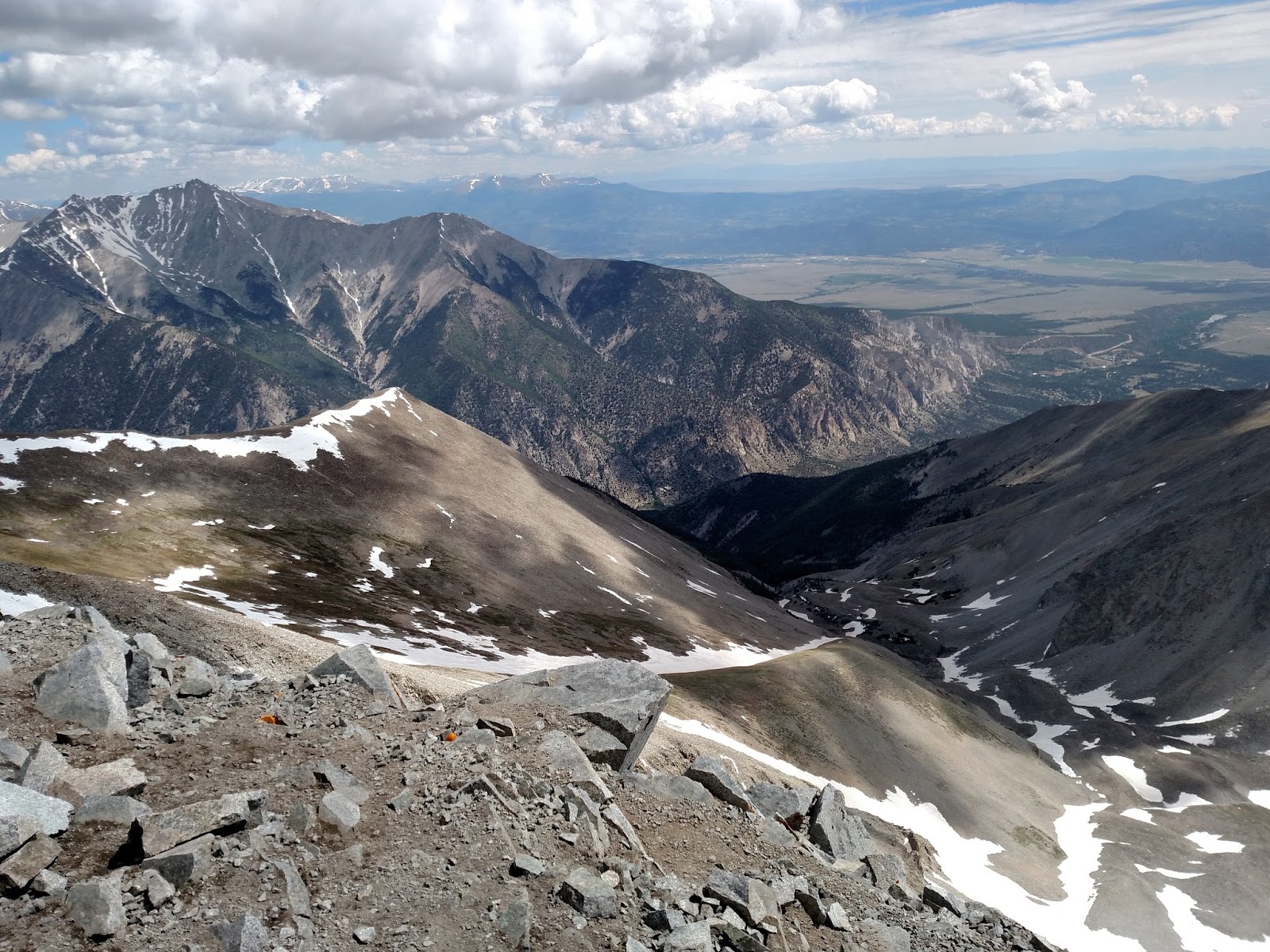
A close up pic to the south. Mt. Shavano is on the left, and Tabaguache Peak is on the right with the snow fields streaming down it.


View to the north. Mt Harvard is the tall peak in the center in the back, with Mt. Columbia to its right. Mt. Yale is a quarter way from the left, slightly closer than Harvard and Columbia. Mt. Elbert is the darker, rounded peak very far in the distance near the left side of the picture, and Missouri Mountain is the snowier peak in the distance on the left edge of the picture.


After about 20 minutes, we headed back down. Once we got past the spine at the base of the summit, it was smooth sailing back down the road, and we cut several corners off the switchbacks to save some time. I always like looking back up to the summit when I can after I'm on my way down because it always seems like it is ridiculously far away, and it gives a real sense of accomplishment knowing that as far as it looks, I was up there.


It took about 2:20 to get back down to the jeep and begin the 4 mile drive back out to good road. It was nearly 2:00 in the afternoon, and we were a little anxious about the creek, as we didn't know how much the water would have risen in the afternoon when I got warmer. Turns out we didn't have any problem, and Nicole carefully made her way back down. Mission accomplished.


I have a few target 14ers I'd like to summit this year, and Mt. Antero was not on that short list, but I was glad that everything came together perfectly and allowed us to bag it, particularly after making such a last minute decision to give it a go. While I'm generally not a great planner, I do try to prepare for more than a couple hours between the mere thought of attempting a summit and actually doing it. This was my 24th summit, and Nicole's 27th (not that I'm keeping track and trying to get back ahead of her or anything). The snow is melting quickly, and it is time to continue exploring the high points of this amazing state. Let the season begin!