Monday, June 25, 2018

Culebra Peak - Snakebit


14,047' Culebra Peak (which means "snake" in Spanish, and since nearly every report I've ever seen regarding this peak includes that bit of information, I figure I may as well keep the tradition alive by doing it here) is unique in that it is part of the private Cielo Vista Ranch, which only allows limited access to the summit of Culebra on weekends during a couple months of the summer. Reservations to climb have to be made in advance, and the 20-25 slots per climbing day usually go very quickly, so I was excited to have been able to get mine right as they were publicly made available. Joining me on this climb would be Nicole Smathers, Kim Styles and Laura Chren.

We drove down to Fort Garland CO the day before so that we could shorten a 4-5 hour drive to the property gate from Longmont to about 45 minutes. After a typical restless night, we headed out about 5:00 am. At 5:45, we met the property manager who let us and maybe a dozen other parties who had camped out at the gate that night onto the property. We drove a couple miles to a ranch house where we checked in, then drove about 4 miles up a relatively easy but steep 4wd road to the upper parking area. By about 6:45 am, we had started hiking.

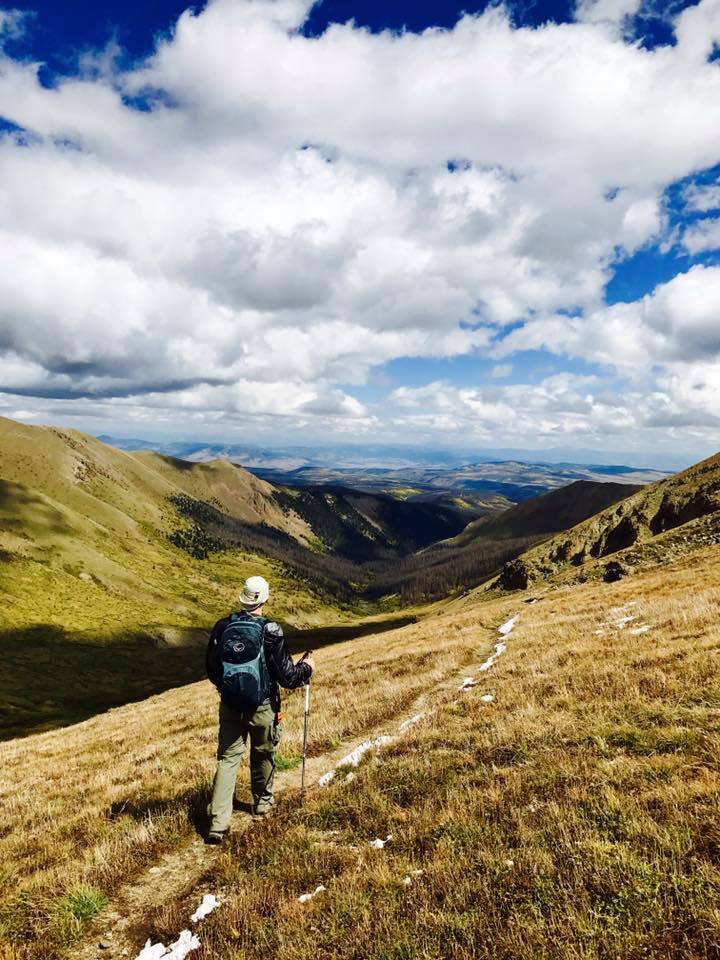
We would be doing the standard NW Ridge route, which is about 5-6 miles round trip but can vary somewhat because there is no trail here, though the path is pretty obvious. Right out of the parking lot, we climbed about 1.4 miles up a 1500 foot slope to reach a ridge at about 13,300'.


The picture above doesn't nearly show how much elevation you have to gain to get to the ridge. Below looks back from maybe 1000' up the face, where the parking lot is out of view just below treeline.


On the ridge, there is a giant cairn to aim for that marks the beginning of a short drop into a saddle before heading up the NW ridge of Culebra as seen in the distance below.


Thankfully a big chunk of elevation was gained to this point, but there was still a good 1000' to climb over this ~1.5 mile ridge.


The views to the north from this ridge were really amazing. Below, 13,436' "Punta Serpiente" can be seen above Carneros Lake to the north. The cairn in the previous pic would be on the left side of the ridge in the pic below, and Punta Serpiente is the high point on the right of this ridge. We would be going to that summit after we were done with our primary task at hand.


The ridge started as rocky tundra but quickly turned into mainly talus, some that required some easy scrambling to get through. Most of the way up, there was a high point ahead that I knew was a false summit, but it made for a good point to aim for.


The true summit couldn't be seen at this point, and even though I knew it was still a good half mile beyond the false summit, it still surprised me how much farther we had to hike to get there.


Fortunately, we only had a couple hundred more feet to gain along this final ridge, so it was a pretty easy finish. The views, as usual at this elevation, were incredible on this clear day.

Looking to the north:


Looking west back along the ridge into the desert-like San Luis Basin. The false summit we had to pass is the hump on the right of the picture:


The Spanish Peaks were visible to the northeast. These 13.5k and 12.6k peaks look spectacular because there is nothing else near them:


To the north, the lower group of Sangre de Cristo 14ers could be seen in the distance (Little Bear, Blanca, Ellingwood Pt, and Lindsey. The Great Sand Dunes can't be seen but are just behind and slightly left of these peaks in the background:


13,908' Centennial Red Mountain, which is about a mile one way from the summit of Culebra, is often combined with it. I had expected to summit it with anyone who wanted to join me, however over the course of our summit of Culebra, the wind had really began to whip up strongly, and none of us felt like traversing to and from Red (one must re-summit Culebra to get back) in a wind tunnel. It would have to wait for another day.


Our group at the summit. I've been on many summits, 14ers and otherwise, with these great friends.


This was my 38th 14er. It is getting more and more difficult to get the required number of fingers in the picture without it looking a bit awkward, but there is no time for awkward when one is documenting 14er ascents.


We spent nearly an hour on the summit, much of it huddled behind a wind shelter refueling, taking pictures and convincing ourselves that we'd be better off not to try to tag Red Mountain. When we arrived, there were about a dozen others on the summit, and as we headed out, one had just returned from Red and another group of 4 had made there way up from the lower trailhead. 

This picture of Kim and Nicole descended shows what much of the upper slope looked like. By now the wind was fierce and pretty constant and made the descent a bit more of an uncomfortable challenge.


In lieu of Red Mountain, we decided to summit Punta Serpiente on the way down, which would add maybe another mile and a hundred feet of gain but would provide us with a new and beautiful perspective of the basin we'd been skirting all morning. In the picture below, the summit of Culebra is the high bump on the right of the pic, a couple miles away.


The view west was still incredible from here. Sanchez Reservoir can be seen in the center in the distance. We would be heading down this rocky talus face to get back to the car.


From our descent on the opposite side of this face on which we started our climb, we could see our initial route that started just below treeline in the bottom of the valley on the right, immediately climbed that ridge near the center, then worked up the ridge to the left side of the picture.


Again, the picture doesn't do it justice, but this was a pretty vast face of tundra, much of it covered with small flowers. This was taken just before we got back to the parking area.


In all, we were out nearly 7 hours over the course of 5-6 miles roundtrip, depending on whose tracking device you trusted the most. Nicole had recently climbed Pikes Peak and was grateful for a much more compact and scenic hike on Culebra. It was her 36th 14er. This was Kim's 20th 14er and first since last year if I'm not mistaken. Laura had been earning her masters in Florida and Mexico over the past couple of years and has recently returned home to Colorado for her first 14er summit since then. Word has it that she'll be out doing a couple more this week.

All of Colorado saw very little snow this winter and much of it is in a severe drought, so summer conditions have come early to most of the tall peaks here this year and there are already some major fires burning. Fortunately the Sangres have not seen fires break out yet, and we were lucky enough to get to enjoy more unique scenery from Colorado's southernmost 14er. 

Monday, December 4, 2017

Pikes Peak - My First "Winter" 14er?


The 2017 climbing season came and went with much less than opportunity than usual for peak bagging, and I had only summited four 14ers. The latest I've ever done one was in September, and here it was December when all the high peaks are usually covered with snow and the hiking often starts miles before the summer trail heads. However, this winter has been particularly dry, and as I followed the peak conditions, there were reports that some routes were getting pretty clear. Pikes Peak (14,110 - 14,115 feet tall, depending on your source) was the last Front Range 14er on my list, and two days before the weekend I saw the words I'd been waiting for in its condition report: "Trail clear". The summit cam confirmed this...it appeared bone dry. And to make it even more tempting, the weather on Saturday Dec 2 in Colorado Springs was supposed to be in the 60s and clear! The weekend looked free, and so I planned by attempt.

Pikes Peak is one of two 14ers on which you can drive to the top, and I've done that. It also has a really cool cog train that I've also ridden to the top. Hiking it is a bit more involved, as the two main routes are 14 and 25 miles roundtrip. The 14 mile northwest slopes route, starting from the Crags Trailhead near Divide CO, is a class 2 hike, 4000+ vertical feet up the back side of the peak. It only very recently reopened after being closed for several weeks to remove a bunch of dead trees that were determined to be a hazard along the road and trail.


One of my former kickboxers was kind enough to put me up for the night in Colorado Springs the night before, so the drive to the trailhead was only about an hour instead of the three it would have been directly from Longmont. Without fear of afternoon weather, I planned to start hiking around sunrise, which ended up being 7:00 AM.

I brought a few layers, including my shell and a winter jacket because I wasn't sure what it would be like that day. The temperature at the trailhead was in the 30s, and with a full pack and an initial climb, my experience was that I wouldn't need the heavy jacket, as the climb would quickly warm me up. And I was right, at least for awhile. The first couple of miles was a pretty gradual incline through the woods. There was a really cool rock formation that the trail skirted around.


I was getting warm to the point that I considered removing my long sleeves, but as I got above treeline, it began to feel a bit colder. The wind wasn't so bad yet, but the sun was still on the other side of the mountain, so it was chilly. Above treeline, the trail climbs a pretty steep slope to about 12,700 feet. It reminded me a lot of Belford, just a relentless slog uphill but without all the switchbacks. I was stopping pretty frequently to catch my breath, all the while noticing the sunlight moving toward me as the sun rose higher. When it finally hit me, I was temporarily recharged and warmed up. I decided I had made the right choice to leave my heavy jacket in the car.

At the top of this ridge, one can see the summit which is still over 3 miles away.


I knew a lot of the climbing was now behind me, and I looked forward to a long, much flatter walk along the road to the summit. At the top of the ridge, the trail passes just below Devil's Playground, and 13er Devil's Playground Peak. It was only a couple hundred feet to the summit, and I planned to go over it on the way back down.


From this point, the route flattens considerably. The trail follows along the road to the summit, and the sections that went downhill felt great after the climb I had just completed. Another 13er, Little Pikes Peak, was next to the trail closer to the summit (see the first picture above, Little Pikes is on the right). This would be another easy bag on the way down.

It was along this stretch that the wind really started to get to me. I put on my balaclava and my heavy gloves along with my winter hat and the hood of my shell, and that helped somewhat as long as I kept moving. I tried to drink every few minutes and blew the water out of my line to try to keep it from freezing, and I only had one "oh crap" moment that it did freeze up but I was able to knead it out before it got too bad. After about 6 miles, the last half mile was the class 2 scramble to the top. The basin below looked amazing.


In the picture above, Little Pikes is right of center along the road, and Devil's Playground is just behind those cliffs on the right. That back ridge is where I had initially come up. Below, the view is more to the southwest, with the southern Sawatch Range and the northern Sangre de Cristo Range in the distance. It was windy, but the view was endless.


The summit block was frosty, and it was slippery and slow going to the summit.


Unfortunately, I had to stop frequently, and I had become very cold with the wind. That last half mile and 1000 feet to the summit took nearly an hour, and the summit is large, flat and very open to the wind, which was howling. I made my way to the summit house and snapped a quick picture of me at the summit sign. 14er number 37 had been bagged.


In the summit house, I was too cold to partake of the world famous donuts that the snack bar boasted. I made my way to a booth, took off my head gear, put my head on my arms on the table and shivered. I had a couple energy bars and rubbed my arms and body to try to warm up. After about 20 minutes I thought I needed at least one picture from the summit, so I made my way to the viewing platform on the east side of the summit and snapped a shot of Colorado Springs below.


The wind was still awful, and I practically ran back into the summit house to try to warm up again. There were several people up there that had driven, and I considered trying to hitch a ride back to Devil's Playground (the road itself went down the east side of the mountain, so Devil's Playground was the last stop via car before the road split from the trail). That seemed like it was cheating, though, but I thought maybe I could at least walk the road down from the summit which was a little longer but much easier travel than going back down the slippery summit block. Unfortunately, a not so subtle sign said "no pedestrians" past the summit on the road. Oh well, back down the way I came it would be.

The scramble down wasn't as bad as I expected, and I was able to take some video once I had a little break from the wind. The 3 miles of flatter trail that were refreshing on the way up suddenly become more challenging with every slight incline on the way back to Devil's Playground. Still, there was great scenery all around.

The summit block behind me:


Looking east down a gully along the road:


A rock formation near Devil's Playground. Many rock formations up here reminded me of Garden of the Gods, which wasn't terribly far away.


From Devil's Playground Peak, looking at the ridge I would drop over. I ended up not summiting this peak nor Little Pikes, it was too windy and I was just too cold.


Looking back across the basin to the summit in the distance.


The top of the ridge had a marker, and from here it was all downhill.


Dropping off the ridge. You could see forever from to the west.


The further down the slope I got, the less wind there was, until finally in the trees it had essentially stopped. The long hike had worn me down, but at least I was warming up again. After 8 hours of hiking and nearly 14 miles, I returned to the trailhead at about 3:30. Mission accomplished.

It seems I am far to frequently under-prepared for some of these hikes. I was aware that it tended to be windy in the winter, but a favorable forecast at lower elevation lulled me into thinking this day would be different. It was not, and next time I'll be better prepared, but this time I was still able to safely summit and return. Colorado could use some snow, but I was glad I could take advantage of the dry conditions to again enjoy the scenery one can only see in the high elevations. As hard as they are, I'm always thankful that I have the ability to do these hikes, and the reward for tackling these challenges is always worth it, without question.

And with that, the extended 2017 14er climbing season appears to have come to an end for me with five total summits. Let the training and conditioning begin for next summer, where the challenges become much greater!


Monday, September 18, 2017

San Luis Peak - Gatekeeper of the San Juans


My list of remaining 14ers is getting smaller, and the ones that are left are typically some combination of very difficult or not terribly accessible. 14,014' San Luis Peak is firmly in the latter category, requiring nearly 25 miles of dirt road driving after driving another 20 miles from the nearest city with any amenities, which arguably is Gunnison. It is not a difficult climb, being one of the few class 1 14er hikes, but it is a pretty long hike at 13.5 miles round trip. This has been a pretty sparse summer for 14ers for Nicole and me, and after some very challenging terrain in the Sangre de Cristos earlier this summer, we were hoping for a relatively mellow "gimme" summit that may well be our final one of the summer.

On Saturday September 18, Nicole and I left Gunnison at 4:45 AM for the two hour drive to the Stewart Creek Trailhead to climb the Northeast Ridge route of San Luis.  We arrived not long after sunrise and were on the trail at about 6:45. The forecast was for a very slight chance of afternoon showers and high winds, but for now it was clear and chilly, about 35 degrees.


The first 4 miles of this hike are very gentle, only gaining a few hundred feet per mile as it follows Stewart Creek up this valley.


The sign in the picture above says "San Luis Peak - 5 1/2". That is complete BS from trail mileage, but maybe as the crow flies. After a couple of miles, we began to see some fresh moose tracks, and a recent trip report said they had seen a couple moose when they were out. And sure enough, we did come across a couple bulls hanging out by the creek. They watched us pass but had no interest in moving from that spot.


After about 4 miles, we left the woods and got a better view of the upper basin that we would soon be climbing out of.


In the picture above, the slope off to the left leads up to 13,800 foot Organ Mountain. The snow crested peak right of center is on the eastern part of the San Luis summit ridge. We would be hiking into the saddle between the two and fortunately would not have to climb either to get to the true summit.

Up to now, the elevation gain had still been really mellow, but about 5 miles in, at the back of the basin, we would have to start some more serious climbing. The first go would be an 800' climb to the saddle between the San Luis ridge and Organ Mountain.


This next picture looks back down the basin from just below the 13.100 foot saddle.


And on the saddle, looking back across the ridge that leads to Organ Mountain.

Ahead of us, we had another 1000' of gain to reach the true summit of San Luis, which is on the far left in the shadow. The snow crested peak in the previous pictures can be seen here on the right side, and the trail can be faintly seen as snow on the lower left shoulder of that peak.


As we trudged up to the ridge, the great dirt trail turned into talus. There were at least 4 humps along this ridge, and we would traverse under the first couple before crossing the ridge to the back side and continuing to work up to the summit.


There had been a little snow the previous week, and with the cold temperatures, there were still some areas of the trail that had a few inches on it, but it wasn't too bad. This is me just below the summit.


And this is Nicole as she reached the summit.


This would be my 36th summit and Nicole's 34th. It took about 4 1/2 hours to get up here. The wind that had been in the forecast, and a taste of which we got as we reached the saddle below, vanished at the summit and we were left with near perfect weather. The leaves were starting to change in the high country, and the views of the San Juans were jaw dropping.

Here is some video of the summit.

This was the view to the west.

Zooming in, you can make out the unique shape of Lake City 14ers Uncompahgre Peak, dead center in the distance, and the shark fin of Wetterhorn Peak just to its left.

This next picture looks down the ridge to the saddle we just climbed. Organ Mountain is on the far right, and you can see the rock formation from a previous picture between Organ and the saddle.

A closeup view of Organ Mountain. We wondered if the name came from the rock formation on the right side of the summit block that looked like a pipe organ.

Looking slightly more to the north, 13,983' Stewart Peak can be seen on the far left. It is the 2nd tallest 13er in the state.

This is the Southeast Ridge of San Luis, looking toward the town of Creede. Another route to San Luis comes up from this direction.


The summit itself was actually pretty small and had a great wind shelter (although we didn't really need it this day). We hung out on the summit for at least 30 minutes, snacking and enjoying the views, before we started to make our way back down at about noon.

The hike down was much quicker than the ascent. Just off trail, we saw this large cairn. You can see the summit of San Luis in the background.

And we got an even better view of the rock formation leading to Organ Mountain.

And then we started our descent from the saddle.

The sun was higher now, and the gold in the vegetation on the wall of the basin really came out now. This is looking back up at the saddle.

We had to cross Stewart Creek a couple times along the way, but it wasn't a big deal.


Once we got back to the woods, we made very quick time coming down. We turned around frequently just to get another look at just how far we had to go today. It was amazing to me just how far away the back of that basin was. In this picture, you can barely make out the tiny looking summit of San Luis right in the middle of the "V" of the basin.


After about 8 1/2 hours and over 13 miles on the trail, we finally made it back to Nicole's Jeep, another successful 14er summit in the books. The weather continued to hold, and the clouds, which had gotten a little more thick, really helped to control the heat of the sun. It was a perfect hike in nearly every way it could have been.

We packed up our stuff and headed out. On the way in we drove across several cattle guards and we saw many cows along the side of the road, but when we came back across Nutras Creek, these cows were in our way and reluctantly moved only after we nudged the Jeep right next to them.


There was a lot of color in the trees surrounding the road and on the mesa we were driving above. We couldn't see any of it on the way in, but we stopped several times on the way out to admire the view. Colors are still not at their peak, but were still incredible.


Our newly bagged peak in the background. Organ Mountain on the left, Stewart Peak on the right, and San Luis, the tallest of the three, actually looks the shortest in the middle.


The San Juans are probably my favorite Colorado mountain range, and I loved getting to see it pretty much in its entirety from over 14,000 feet in an area I've never been near before. San Luis is arguably the most isolated 14er in the state, and on this beautiful September weekend, we saw just four other people on the trail the whole day. The traditional fall 14er hike continues another year, and it was one I won't soon forget.